

Plans & Strategies
Hatt Street Functional Design Study

Contact Us
Carson McKean, P.Eng.
Project Manager, Design
Engineering Services Division
Email [email protected]
Call 905-546-2424 Ext. 5644
Hatt Street (From Bond Street to East End/Main Street) & Bond St (From King Street to Hatt Street) requires a full reconstruction due to the condition of the pavement and watermain and to incorporate Complete Street Design Guidelines (2022), namely, to improve multi-modal user safety.
To guide the future Detailed Design of Hatt Street and Bond Street, a Functional Design of the surface features of the road corridor will be undertaken.
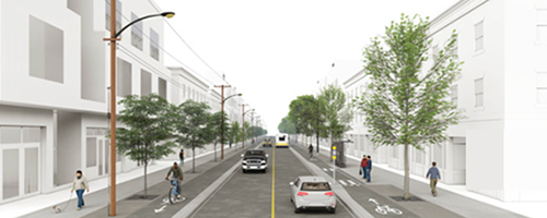
The Functional Design will consider upgrading the Streetscape Features such as:
- Bike lanes
- bump outs
- planting zones
- placemaking
- on-street parking
The Functional Design is reviewing the corridor functionality, and finding the balance of Active Transportation features within space constraints through the Complete Street Guidelines and associated Master Plans.
Public Information Centre
Held July 21, 2026
Presented proposed road configuration concepts for the Hatt Street corridor between Bond Street and Main Street. The concepts were accompanied by an evaluation of design alternatives, and feedback was gathered from residents, businesses, and key stakeholders.
Presentation Materials:
Responses summarize key topics raised including traffic, safety, access, parking, cycling, landscaping, utilities, and project timing.
1. Will the City be conducting an updated traffic study for Hatt Street?
The City has previously completed a traffic study that included analysis of the Hatt Street corridor. These results are reviewed regularly, and the City will ensure that traffic data and analysis are current and relevant as the project moves into detailed design. The study evaluated traffic volumes, travel patterns, pedestrian activity, and traffic operations. It also considered movements within nearby communities and broader traffic patterns to inform the results.
2. How will the proposed design improve safety while maintaining traffic flow?
The project team is evaluating Complete Streets principles as part of the functional design. This includes traffic-calming measures such as curb extensions, improved pedestrian facilities, and cycling infrastructure.Curb extensions visually narrow the roadway, encouraging drivers to reduce speed while travelling through the corridor. They also shorten pedestrian crossing distances by reducing the number of active travel lanes pedestrians must cross. Cycling lanes are proposed behind the curb and separated from active traffic lanes, improving safety and comfort for cyclists.
3. How will trucks, buses, and other large vehicles be accommodated?
The design team will use AutoTurn software to simulate the space required for trucks, buses, and other large vehicles to navigate the roadway safely. Hatt Street is designated as a truck route in the City’s Transportation Master Plan, and the intent is for it to remain a truck route. The design will therefore continue to account for safe truck movements through the corridor. Roadway maintenance requirements, including winter plowing, will also be considered. City operations staff will review the design and provide feedback to ensure operational needs are addressed.
4. Will local businesses, industries, and property owners continue to have access during construction?
Maintaining access to businesses, industrial properties, medical offices, driveways, and parking areas has been identified as a priority. Construction staging plans will consider property access needs and provide advance notice of any temporary restrictions where required. While some short-duration access limitations may be necessary during construction, the City will work to provide appropriate accommodations.
5. What changes are being proposed for parking, and how will parking impacts be managed?
The proposed functional design is expected to reduce the overall number of on-street parking spaces along Hatt Street. Curb extensions at intersections will move parking farther away from intersections and reduce the available curbside space for parking. Parking needs, including those of homes without driveways that rely on street parking, will continue to be evaluated as the design advances. The City will continue communicating with stakeholders about potential parking-related impacts.
6. Why are cycling facilities being proposed?
Cycling facilities are being proposed on Hatt Street based on recommendations in the City’s Cycling Master Plan. The cycling lanes will provide a connection to the Spencer Creek Trail and support active transportation along the corridor.
7. How will trees, landscaping, and community character be incorporated into the project?
The redesign of Hatt Street will emphasize opportunities to preserve and enhance the streetscape through tree planting, landscaped boulevards, and urban design features. The project team will consider existing environmental conditions, previous urban design work, and opportunities to create an attractive transition between residential, commercial, mixed-use, and industrial areas. Proposed curb extensions and available boulevard areas may provide additional opportunities for landscaping. The design team will also look for opportunities to acknowledge the history of Hatt Street, including the historic presence of the railway through the corridor.
8. What is the project timeline, and how will residents stay informed?
The City intends to complete the functional design and preliminary design by the end of 2026. The preliminary design will outline potential construction staging and scheduling. At a high level, detailed design is expected to begin in 2027, with construction potentially beginning as early as 2029. Additional public correspondence will occur during detailed design, giving residents another opportunity to review and comment on the proposed design.
9. How will utilities be impacted?
The proposed design will be circulated to utility providers for review and comment on potential impacts within the corridor. Utility impact plans will be developed, and the design team will coordinate with providers to determine whether relocations or improvements are required. City infrastructure, including storm sewer, sanitary sewer, and watermain systems, will be evaluated for sizing and remaining service life. At this stage, the work is focused on developing an appropriate cross-section and functional design. Detailed design will further assess underground infrastructure, and high-level storm sewer design will be completed to evaluate how road alternatives collect and manage stormwater.
Date modified