Airport Employment Growth District Transportation Master Plan
Margaret Fazio, Senior Project Manager
Infrastructure Planning
Call 905-546-2424 ext 2218
Email [email protected]
Omar Shams, Senior Project Manager
Mobility Planning
Call 905-546-2424 ext 7474
Email [email protected]
The City of Hamilton has completed the Airport Employment Growth District Transportation Master Plan Update (AEGD-TMP Update) Municipal Class Environmental Assessment (EA) Study. The AEGD TMP Update identifies policies, programs and infrastructure improvements needed to manage both existing and future transportation demand for the business park.
Environmental Assessment Process
This Transportation Master Plan was undertaken in accordance with the master planning process of the Municipal Engineers Association’s Municipal Class Environmental Assessment Document (MCEA, 2001, last amended 2023).
The 2023 AEGD TMP Update fulfills requirements of the Approaches 1 and 2 of the master planning process.
Revised Project File Report, Appendices & Mapping - June 2024
- Project File Report for AEGD Transportation Master Plan Update (PDF, 6.96 MB)(See Addenda at the beginning of report for full details)
- Cross Sections
- Conceptual Two-Lane Collector Road - Total Right-of-Way Width = 30m(PDF, 493.71 KB)
- Conceptual Four-Lane Collector Road - Total Right-of-Way Width = 36m(PDF, 353.29 KB)
- Conceptual Two-Lane Arterial Road - Total Right-of-Way Width = 36m(PDF, 341.02 KB)
- Conceptual Four-Lane Arterial Road - Total Right-of-Way Width = 45m(PDF, 335.77 KB)
- Conceptual Six-Lane Arterial Road -Total Right-of-Way Width = 50m(PDF, 328.89 KB)
- Appendices
- Appendix 1 - Stage 1 Archaeological Assessment(PDF, 8.9 MB) - Sep 2023
- Appendix 2 - Built Heritage and Cultural Landscape Report(PDF, 24.28 MB) -Sep 2023
- Appendix 2 - Cultural Heritage Report(PDF, 65.95 MB)
- Appendix 3 - Collector 6N Feasibility Study(PDF, 2.58 MB) - Sep 2023
- Appendix 4 - Public Engagement Compendium(PDF, 80.06 MB)
- Appendix 5 - Network Scenario Model Outputs(PDF, 440.54 KB) - Sep 2023
- Mapping
A Project File Report for the Airport Employment Growth District (AEGD) TMP Update provides a full account of the planning and decision-making processes associated with the revised multimodal transportation network. This report also outlines the updated network phasing and the anticipated timeline for implementation of each project, along with the additional EA study requirements.
Project File Report, Appendices & Mapping (September 2023)
Project File Report for AEGD Transportation Master Plan Update(PDF, 5.02 MB)
Appendices
- Appendix 1 - Stage 1 Archaeological Assessment(PDF, 8.9 MB)
- Appendix 2 - Built Heritage and Cultural Landscape Report(PDF, 24.28 MB)
- Appendix 3 - Collector 6N Feasibility Study(PDF, 2.58 MB)
- Appendix 4 - Engagement Compendium(PDF, 9.18 MB)
- Appendix 5 - Network Scenario Model Outputs(PDF, 440.54 KB)
Mapping
- Road Network Map(PDF, 3.12 MB)
- Active Transportation Network Map(PDF, 2.55 MB)
- Conceptual Transit Network Map(PDF, 1.07 MB)
- Road Network Implementation Phasing Map(PDF, 2.99 MB)
Staff Reports to Committee & Council
AEGD TMP Update - City Council November 8, 2023
AEGD TMP Update - Planning Committee Meeting of October 31, 2024
By 2031, planned growth in the Hamilton Airport Employment Growth District (AEGD) is expected to reach over 23,843 employees. The 2011 Hamilton AEGD Transportation Master Plan (TMP) was undertaken to prepare a transportation strategy that would suitably accommodate these employment projections and the City of Hamilton’s long-term vision.
The AEGD will be developed in two development phases to coincide with water, wastewater, and transportation infrastructure development phasing.
AEGD Transportation Master Plan Update
The objectives of the AEGD TMP update were included:
- Review and update of the multimodal transportation strategy that supports development and vision of the AEGD, in alignment with the guiding principles of the city-wide Transportation Master Plan
- Re-affirm identified problems or opportunities and recommend alternative solutions to transportation issues anticipated for 2031 horizon year and beyond
- Modify the AEGD road network to enhance network connectivity, increase redundancy; and address capacity constraints
- Identify and protect future transportation corridors in relation to ongoing development since 2011/2016, implementability, road functional classification and associated Municipal Class Environmental Assessment (EA) classification.
- Integrate policies, programs, funding and infrastructure needs;
- Determine preliminary cost estimates for transportation infrastructure improvement projects in relation to proposed network changes;
- Review and update the transit network and Transportation Demand Management (TDM) measures and guidelines previously recommended for the AEGD
- Increase Cycling/Pedestrian/Trails network connectivity to support active transportation needs throughout the AEGD.
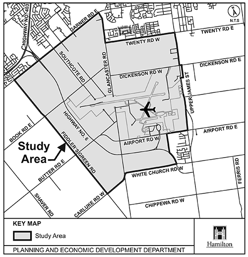
This provincially significant employment land is located southwest of the City of Hamilton Urban Area, encircling the Hamilton International Airport (HIA). The study area is characterized primarily by existing agricultural and rural residential lands. The preferred Land Use option proposed for the AEGD lands provided approximately 742 net hectares of employment land to serve the needs to 2031 and 1,271 to serve the demands beyond 2031.
AEGD Master Plan (2011)
Update to Conceptual Cross-Section Design for Roadways
Since the first PIC in May 13, 2021, staff have developed refined conceptual cross-sections to address requirements of the AEGD Stormwater Master Plan / EcoIndustrial Design Guidelines and the recently approved Complete Livable Better Streets Design Guideline, etc. These refinements, driven by the need for roadside swales to convey stormwater and provide better opportunities for road user safety, have resulted in changes to the approved conceptual cross-sections and Right-of-Way widths within the study area. View the updated Conceptual Cross-Sections(PDF, 1009.71 KB)(PDF, 1009.71 KB).
Virtual Public Information Centre #1
Held May 31, 2021
Introduced the study, and offered an opportunity to comment on the study evaluation process and updated proposed collector and arterial road network.
Presentation Panels(PDF, 1.77 MB) | Alternative 1: Do Nothing(PDF, 1.24 MB) | Alternative 2: Proposed Revised Network(PDF, 1.24 MB) | Preferred Alternative(PDF, 1.24 MB) | Integrated Trails and Pedestrian Network(PDF, 1.24 MB) | Evaluation Table per Road Link (PDF, 560.17 KB)